| |
南京管道修复公司,专业承接管道修复,顶管置换,光固化修复,排污管道疏通 ,雨污管道检测,管道CCTV检测,管道QV检 ...


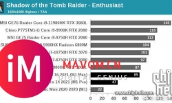
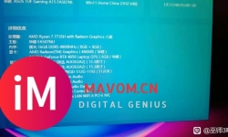
转:M1 MAX评测解禁,GPU相当于3060? CHH水区看到的,这个成绩大家满意吗?不过说实在的MAC OS本来就基本和游戏无缘 ...


在 Apple 生态中,Infuse 一直是一款比较优秀的影音播放器;VidHub 则凭借本地化体验与价格优势获得用户青睐。 这篇文 ...

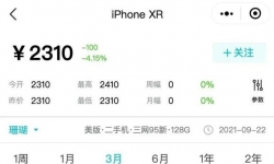
今日说机:iPhone XR iPhone XR,最近几个月价格一直稳定在1800-2000元起售的价格,可以说是非常保值了,而且市场上经 ...

深圳罗湖统建楼【湖畔山庄】 价格:45000元/平 面积:85-100-130-148-180平 规模:11栋合围花园,三层地下车库(车位1 ...

Ai 2019-2025安装包(Adobe Illustrator 2019-2025)安装包永久免费版下载安装教程 Adobe Illustrator Ai-2019-2025, ...


我不care什么月感电,我只想知道我❤️能不能with到?! 我❤️1.0时期手段很美四升五改建模 2.0时期带千岩讨龙给淋🌸 ...


MacBook pro m3max有512bit内存和miniled这两个debuff,续航都没拉,所以就别拿oled和高刷给你高通碟洗地了。 ...


嘿,小伙伴们!今天电脑天空给大家安利一款超神奇的音频小能手——AudioRelay!要是你和我一样,经常在各种设备之间 ...

我是之前买了个x200s,发现屏幕的色准,饱和度,护眼这些完全比不过老手机k50,刚去ai问了下参数,发现k50是三星屏啊 ...


#教资#💯21下中小幼科目一/二考前狂背十页纸来啦 👊🏻每科考前考点仅10页纸 ⭐多拿一分,干掉千人 临阵磨枪,不快也光 ...

ねえ どんな険しい旅道でも🎵 最果は未だ遠くても🎵 これからも隣で キミと同じ未来を見させてよ🎵 然而并没有约誓语 ...


🎀一手【全球购入驻】新老店铺,流程简单,价各有优势,100%轻松起量十w+。 🎀百类【品牌授权】任挑选,0成本,高回报 ...

今天,Blender基金会在其官网宣布VR/MR设备开发商PICO现正式为其企业赞助商。这是首家中国企业加入Blender基金会。也 ...

【礼盒+调包扣+香片】KAILAS/凯乐石 博格达LT 冲锋衣硬壳轻量防风防水户外徒步登山外套 轻量升级的徒步型冲锋衣,提供 ...


iPhone 13 Pro 256G 远峰蓝用户体验 1. 等待时间是漫长而煎熬啊 9.17 20:33下单 10.14 下午17:20 收到货 着实等的让人 ...

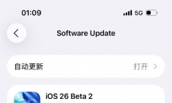
不知道为什么,之前从15到15.0.1很快,然后15.0.1到15.0.2就很慢,不过也能更新,现在到15.1压根就显示不出来,储存够 ...


产品概述 LEONARD GSW100-06 MNSG GV3:1L 是一款专为工业旋转设备设计的 高精度、高可靠性限位开关,适用于监测减速箱 ...

看到大佬发的图片突然有个大胆想法——把deepseek变成会动的桌宠精灵!想要实现以下效果: ✅ **常驻桌面**:像动态壁 ...

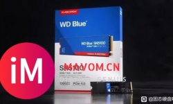
闪迪推出了新一代 WD Blue SN5100 固态硬盘,依旧采用 PCIe 4.0 规格,但相较于上一代 SN5000 性能提升高达 30%,定价 ...

CPU899:INTEL i5-12600KF主板769:华硕 ASUS B760M AYW DDR4 WiFiGPU4799:微星 RTX4070S 12G DUKE 暗黑龙爵内存286:爱 ...

iPhone 13 pro,激活不到10天, 电池满电的,突然弹出个全屏提示我,电池电量低,请及时更换电池! 我整个人方了。怎 ...

想买个新鼠标因为老鼠标感觉续航不太行,之前用的类gpw想试试人体工学看中了这款雷柏vt3s 189和vt3smax 289,差了100 ...


要让《代号RIDER》电脑版运行更流畅、稳定,可以使用MuMu模拟器,不仅能在电脑上流畅运行,还支持键位设置、多开运行 ...

 微信扫一扫
微信扫一扫